As the Idaho Conservation League’s artist in residence for 2019, my task for the year is to paint Idaho. I want to showcase the diversity of our state’s landscape.
To do that, I need to see the state! Seems like the logical conclusion, doesn’t it? Even though I’ve seen quite a bit of the state during my 40 years here, I know I haven’t seen it all. Thus, my goal is to see as much as I can.

For my first big trip of the year, I decided to follow the Snake River. ICL has made the Snake River one of its top priorities for the next several years; to restore salmon runs and to clean up the river in sections where pollution has made it dangerous for all species, including us.
I set out to see as much of the canyon of the river as I could, or as anyone could who traveled by car. I also want to make the case in my artwork that a person needn’t have to don a 50 lb backpack and trek 30 miles in order to see something exhilarating or inspiring in Idaho. And even though conservation often means setting aside or protecting special lands of stunning beauty, I think the core values of conservation can apply to almost anywhere humans find solace and connection, even if those areas are in one’s backyard.
I assumed the Snake River would be one of those Idaho areas accessible to everyone. After all, it runs through the most populous sections of the state. Only in Hells Canyon below the dams do you need either a permit to raft that section or to hire a jet boat to whisk you through.
I started at Palisades Dam on the border with Wyoming. Nestled in a lovely canyon southeast of Idaho Falls, a giant plug regulates the flow of Wyoming’s water.
The river’s canyon below the dam tells us how beautiful all the canyon once was. Flowing from the dam’s base, the Snake runs along rock cliffs, broad stands of several species of trees, especially cottonwood, diverts around islands, and cradles flocks of various fowl. It feels northwest; moist, green, verdant, and intimate. I found Kelly Canyon Road, a gravel road on the north shore that traverses its length from near the dam to the town of Heise. Several campsites populate the bank as the road never strays from the river.

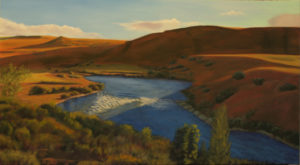
Carl Rowe painting.
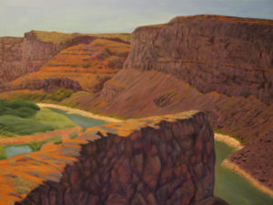
Following the Snake through the cities of Idaho Falls, American Falls and Burley reveals that seeing it’s canyon is problematic. Access to the canyon of the Snake is rare. This is not The People’s River. Private land blocks most of its banks for a couple of hundred miles. Most is agricultural. The Snake is a working river; dammed, pumped, drained, poured into, and sometimes beat up. Its canyon varies from deep, narrow cuts to wide lazy flat land. Sometimes its water is barely below its surroundings. Sometimes its canyon lay camouflaged until you happen on its rim, revealing a spectacular basalt crevice with a “way down there” streak of water. Sometimes the current swiftly tumbles over rock, as if an actual happy river. Other times what current it has inches along invisibly, more lake than river.
Some areas hinted at the river’s character. I savored those times when the Snake looked and acted like a river: fast current, shorelines of vegetation, islands with pelicans and cranes, interesting rocky canyon walls, and clear, inviting water.
What canyon rim isn’t off limits by agriculture is off limits by development. The canyon between Hagerman and Burley is the Snake with the most eye candy. Towering walls with bursting waterfalls, volumes of water in the river bed rather than the trickles upstream. However, savor when you can get near it. Private homes line the rims: Eagle Estates kind of places. One lot deep and a mile and a half long. “No Trespassing.”
While I did manage to find the rim on the south side I was traveling along, I had to do so by driving numbered county roads until I found a cross road that went in the canyon’s direction. Several times those roads ended in a field, a gravel pit or someone’s yard. Only rarely did I finally get to see what the canyon looked like in that area, often on a patch of vacant land yet to receive its home. Those folks have a great view, I can tell you, but you will have to work hard to find it for yourself.
The canyon is grandest in that Hagerman to Burley section. You may well know the bridge linking northern Idaho to Twin Falls, the Perrine Bridge. We had to build that bridge or Twin would be part of Utah. East of Burley the river more resembles a long flat lake with no canyon. West of Burley is the Murtaugh section where you can cross a bridge and see it well. There it seems as if all the canyon wall rocks are trying to occupy the river bed. When I was there the river was more creek than river and a small creek at that. During spring, however, that section is a torrent of deadly rapids.
In my wanderings toward Marsing, the highlights were the section east of Clear Lake Country Club, Hagerman, Massacre Rock State Park, and anywhere around Twin that allows you to the river, aside from jumping off that bridge. As I tried and mostly failed to get near the river further west, I realized that often the Snake is a desert river. Whatever water remains to keep flowing west seems the only water for miles in any direction. I traveled along a rugged pole line gravel road for far too long hoping I could see the canyon east of Grand View. Only once did I get a brief long-distance view.
Swan Falls is a lovely place, west of the dam. I saw no swans nor falls, but the canyon below the dam at sunset stirs the emotions. Then, once again, getting near the canyon en route to Marsing proved elusive. That’s the Snake’s story.
As for the ICL’s concerns; even without testing the waters for alien compounds I could see why they would be there. At one point when I managed to drive several miles to gain access to the south rim and look across a deep and delightful canyon to the north rim, I saw one of the “thousand springs” gushing a few feet below the far rim. Just above that spot, directly above that spring, resided a feed lot dairy. Several hundred cattle did their thing right above the spring.
The Snake River is the life blood of southern Idaho. Its dams fuel the farming and dairies. It’s a good deal for those farmers, all that water. Without the Snake, they would rely on what comes from the sky onto their land in a desert land that gets 12 inches of moisture a year. I’m not sure what crops they would grow if that were the case, but I doubt we’d be right behind Wisconsin and California in dairy production if it were.
Traveling along the Snake is like listening to Caruso on old 78’s. You can catch glimpses of the magnificent river it most certainly was before we got so excited about plugging it up, building along it, closing it off, and dumping stuff into it. That grand river is still there, in sections. But it’s not like hearing Caruso belting out an aria in the same room with you. It’s more a scratchy, thin voiced impression of the Italian’s once commanding voice.

